


California company trumpets Federal funds to conduct sea level rise effects on Wake Island.
https://www.globenewswire.com/news-r...-Airfield.html
The science of quantifying risk from climate change has matured, and at facilities like Wake Island we can accurately anticipate and mitigate risks from future storms in great detail, said Rich Sorkin, CEO of Jupiter. With the new Biden Administration, we expect that Jupiters work in the public sector will accelerate, and we look forward to a new era of government engagement.From the Department of Interior website.Much of the disruption we anticipate from climate change will occur within a 50-year time horizon, with some effects already being felt in the Pacific, Sorkin said. Just as the military is a driving force around the adoption of many of todays technological advancements, we anticipate that the Air Forces early adoption of climate analytics and resilience planning will be a model for other public- and private-sector institutions moving forward.
https://www.doi.gov/oia/islands/wakeatoll
Bold emphasis mine. So the atoll is pretty flat at about 6 meters above sea level.Elevation
Maximum elevation on the atoll is 21 feet, with an average height of 12 feet above sea level. The outside, seaward face of Wake Island maintains a fairly uniform elevation of approximately 18 feet with a gradual slant to the center of the island and then to the lagoon side.
There are three high points in the atoll, all above 20 feet: on Wake Island at Heel Point, on Peale Island at the seaward side about 500 yards from Toki Point and on Wilkes Island at the lagoon side some seven hundred 50 yards from Kuku Point.
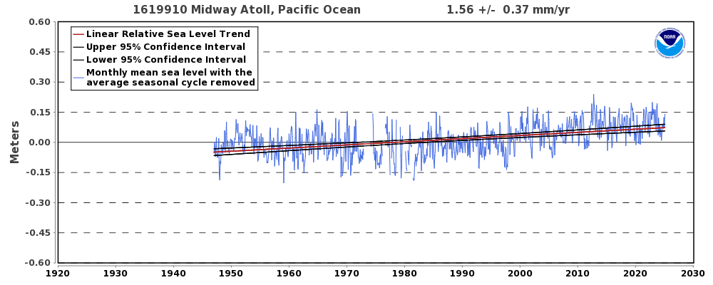
NOAA Tidal Gauge Data from Wake.
https://tidesandcurrents.noaa.gov/sl...tml?id=1619910
So, over the past 72 years, the change in sea level has been pretty steady at 1.5mm/yr. Over the next 50 year we can expect a further rise of 75mm, resulting in a change of average height of 6 meters to 5.925 meters.
Can I get $5M for my conclusive analysis?
XNN

 Reply With Quote
Site Information
About Us
- RonPaulForums.com is an independent grassroots outfit not officially connected to Ron Paul but dedicated to his mission. For more information see our Mission Statement.
Connect With Us